










Panchkula’s Sector 22 side has a calm but purposeful business rhythm. It is not as crowded as older commercial pockets of Chandigarh, but the area still sees steady movement of office employees, cabs, autos, buses, private vehicles, service staff, and visitors travelling between Panchkula, Chandigarh, Zirakpur, Mohali, and nearby Haryana-Himachal routes. The backdrop of the Shivalik foothills, the Ghaggar river belt, and the Nada Sahib side gives this location a different character from a usual city office zone.
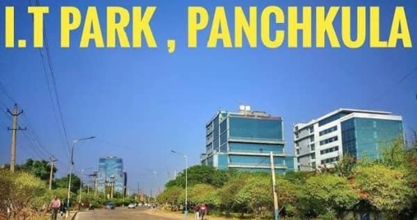
In this growing Tricity business setting, Panchkula IT Park is one of the important technology-focused destinations in Haryana. It is also known as Panchkula Tech Park or HSIIDC Technology Park. The park is useful for IT offices, interviews, client visits, vendor meetings, business operations, and daily office travel.
Panchkula IT Park Quick Overview
| Details | Information |
| Name | Panchkula IT Park |
| Also Known As | Panchkula Tech Park / HSIIDC Technology Park |
| City | Panchkula |
| State | Haryana |
| Main Location Belt | Sector 22, Panchkula |
| Landmark Reference | Behind Nada Sahib Gurudwara side |
| Property Type | IT Park / Technology Park / Commercial Office Zone |
| Developed By | HSIIDC |
| Useful For | IT offices, interviews, meetings, client visits, vendor work |
| Main Road Access | Panchkula sector roads, Chandigarh-Panchkula routes, Zirakpur side roads |
| Nearby Railway Access | Chandigarh Junction, Chandi Mandir Railway Station |
| Nearby Airport Access | Shaheed Bhagat Singh International Airport, Chandigarh |
| Nearby Areas | Sector 20, Sector 21, Sector 22, Nada Sahib, Zirakpur, Chandigarh, Mohali |
| Nearby Facilities | Offices, hospitals, residential sectors, local shops, food points, autos, cabs, buses |
Where is Panchkula IT Park Located?
Panchkula IT Park is located in Sector 22, Panchkula, behind the Nada Sahib Gurudwara side. The park was established in 2008, and HSIIDC had acquired land from the Haryana Urban Development Authority in 2007 before allotting sites to companies.
The park is also described as Haryana State Industrial and Infrastructure Development Corporation Technology Park. It spreads over around 74 acres and is located on the foothills of the Shivalik range and near the Ghaggar River belt.
For visitors, the best map searches are “Panchkula IT Park,” “Panchkula Tech Park,” “HSIIDC Technology Park Panchkula,” “IT Park Sector 22 Panchkula,” or the exact company name inside the park. Since the area has different office plots, internal roads, and nearby sector references, anyone going for an interview, onboarding, client meeting, or vendor visit should confirm the exact company name, plot number, gate, and reporting point before starting.
Why Sector 22 Panchkula is a Strong Business Location
Sector 22 Panchkula is useful because it sits close to the Chandigarh-Panchkula-Zirakpur movement belt. Panchkula itself is part of the Chandigarh Tricity region along with Chandigarh and Mohali. The city is a planned urban area and is located close to Chandigarh, Zirakpur, Mohali, Pinjore, Kalka, and the Himachal Pradesh side.
The location is especially practical for companies that want access to Haryana, Punjab, Chandigarh, Himachal Pradesh, and Delhi-side movement. Panchkula IT Park is also described as well connected to Delhi, Haryana, Punjab, and Himachal Pradesh, which makes it useful for regional business operations.
The surrounding belt also has residential sectors, hospitals, schools, local markets, religious landmarks, and road links towards Chandigarh and Zirakpur. This gives the park a more settled ecosystem rather than the feel of an isolated office area.
Road Connectivity to Panchkula IT Park
Road connectivity is one of the biggest strengths of Panchkula IT Park. The park can be reached through Panchkula sector roads, Nada Sahib side roads, Zirakpur-side routes, Chandigarh-Panchkula connecting roads, and nearby access towards Kalka and Pinjore.
People coming from Chandigarh can use Madhya Marg, Housing Board Chowk, Manimajra, or other connecting routes depending on their starting point. Visitors from Zirakpur can travel through Peer Muchalla, Sector 20 side, or Panchkula connecting roads. From Mohali, the route generally passes through Chandigarh, Zirakpur, or airport-side roads depending on traffic.
Visitors from Kalka, Pinjore, Baddi, or Himachal Pradesh side can use the highway-side approach towards Panchkula and then connect to Sector 22. From Delhi or Ambala side, travellers usually enter through Zirakpur or Chandigarh-Panchkula routes before reaching the park.
Traffic can slow down near Housing Board Chowk, Manimajra, Zirakpur, Sector 20, airport-side roads, and busy Panchkula junctions during office hours. Recent local reports have also pointed out congestion and parking pressure in parts of Panchkula, so visitors should keep extra time for peak-hour movement, gate entry, parking, and visitor registration.
Metro Connectivity
Panchkula does not currently have an operational metro system. For now, visitors depend mainly on road, bus, cab, auto, and railway connectivity.
However, metro connectivity is important for the future of the Tricity. The approved Chandigarh Metro project is planned to serve Chandigarh, Panchkula, Mohali, Zirakpur, Pinjore, and nearby areas in phases. Phase 1 includes a line connecting ISBT Panchkula towards Panchkula Extension, with planned stops around Geeta Chowk, ISBT Panchkula, Maheshpur Road, Amartex Road, Sector 20 Panchkula, and Panchkula Extension Sector 28.
For now, this is not a direct travel option for daily commuters to Panchkula IT Park. Until metro services become operational, cabs, autos, buses, and private vehicles remain the main choices for reaching Sector 22.
Bus Connectivity
Bus connectivity is useful because Panchkula is part of the larger Tricity movement network. Local and regional buses connect Panchkula with Chandigarh, Zirakpur, Mohali, Pinjore, Kalka, Ambala, Delhi-side routes, and Himachal-side movement.
For Panchkula IT Park, daily employees can use buses up to suitable Panchkula sector points, Nada Sahib side, Sector 20 side, or nearby main roads, and then complete the final stretch by auto, cab, e-rickshaw, or private vehicle. For first-time visitors, a direct cab or auto from a known point may be easier than depending only on bus stops.
People coming from Chandigarh can use bus routes towards Panchkula or Manimajra side and then take local transport. From Zirakpur or Peer Muchalla, local road transport is usually practical because the distance is comparatively manageable depending on traffic.
Railway Connectivity
Railway connectivity is practical through Chandigarh Junction and Chandi Mandir Railway Station. Chandigarh Junction serves the Chandigarh region and has regular train connectivity, while Chandi Mandir station serves the Panchkula side and Chandimandir Cantonment area.
For most outstation visitors, Chandigarh Junction is usually the more useful railway point because it has broader connectivity and better transport availability. From there, visitors can take a cab, auto, or bus towards Panchkula IT Park. Chandi Mandir station can be useful for some routes, especially if the train stops there and the visitor is travelling light.
A recent report also mentioned inconvenience on the Panchkula side of Chandigarh railway station because passengers had to walk due to limited short-duration pickup access, so visitors with luggage should check pickup arrangements before planning the final stretch.
Airport Connectivity
The nearest major airport is Shaheed Bhagat Singh International Airport, Chandigarh. It serves the Chandigarh metropolitan region and is located in the Mohali-side airport area.
For business visitors, consultants, and outstation employees, direct cab travel from the airport is usually the simplest option. The route may pass through airport-side roads, Zirakpur, Chandigarh, or Panchkula connecting roads depending on traffic.
During peak hours, travel time can increase near Airport Road, Zirakpur, Tribune Chowk side, Chandigarh-Panchkula junctions, and Panchkula sector roads. If the visit is for an interview, client meeting, onboarding, or formal reporting, it is better to keep a proper time buffer.
How to Reach Panchkula IT Park from Major Areas
From Chandigarh, visitors can travel through Manimajra, Housing Board Chowk, Madhya Marg, or other Chandigarh-Panchkula connecting routes depending on their starting sector.
From Zirakpur, the route can connect through Peer Muchalla, Sector 20 Panchkula side, or other local roads towards Sector 22. This is usually practical by cab, auto, or private vehicle.
From Mohali, visitors can travel through Chandigarh, Zirakpur, or airport-side routes depending on traffic. Direct cab travel is usually easier for first-time visitors.
From Chandigarh Railway Station, visitors can take a cab or auto towards Panchkula IT Park. From Chandi Mandir Railway Station, local road transport can be used if the train route is suitable.
From Chandigarh Airport, a direct cab is usually the most comfortable option, especially with luggage. From Delhi or Ambala side, visitors generally enter through Zirakpur or Chandigarh-Panchkula routes and then continue towards Sector 22.
From Kalka, Pinjore, or Himachal side, travellers can use the highway route towards Panchkula and then connect to the IT Park through sector roads.
Nearby Landmarks and Facilities
Panchkula IT Park benefits from the wider Sector 22-Nada Sahib-Zirakpur-Panchkula ecosystem. Nearby references include Nada Sahib Gurudwara, Sector 20, Sector 21, Sector 22, Peer Muchalla, Ghaggar River side, Panchkula residential sectors, Chandigarh, Zirakpur, and Kalka-Pinjore side movement.
The area has offices, hospitals, residential societies, schools, local shops, food points, autos, cabs, buses, and road access towards Chandigarh and nearby states. Panchkula also has private healthcare facilities around different sectors, and Paras Hospital is listed in the HSIIDC Park, Sector 22 area, which makes the locality easier to identify for many visitors.
For first-time visitors, the best approach is to confirm the exact company address and map pin, then choose the route based on whether they are coming from Chandigarh, Zirakpur, Mohali, railway station, airport, or Delhi-Ambala side.

Job chaye